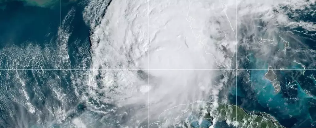
As we transition into a more tumultuous period of the Atlantic hurricane season, environmental experts emphasize the significance of closely monitoring emerging weather patterns and climatic conditions. Following a notably calm August, the Atlantic region is now witnessing the rise of Hurricane Milton, which has escalated to a Category 4 storm. Milton is anticipated to make landfall in Florida on Wednesday night, further complicating the state’s recovery efforts from the recent turmoil caused by Hurricane Helene. Such consecutively powerful storms raise alarms among meteorologists and climatologists who urge preparedness and vigilance as more disturbances are likely to manifest before the hurricane season concludes.
Historically, the peak of hurricane activity occurs around mid-September; however, this year paints a different picture. After several weeks of relative quiet, marked by a lack of named storms from mid-August to early September, the seasonal silence has yielded to vibrant meteorological activity. Experts from the National Oceanic and Atmospheric Administration (NOAA) voiced their initial predictions in May, warning of an anticipated busy season, a sentiment reaffirmed amidst the early storm activity seen earlier in the year with Hurricanes Beryl, Debby, and Ernesto.
The transition into a dynamic phase of storm development can often be attributed to shifting climatic and weather patterns. One such factor is the displacement of Africa’s monsoon season, which typically supplies the necessary atmospheric moisture required for storm formation over the Atlantic. The summer of 2023 witnessed an unusual migration of this monsoon northward into drier territories, limiting its capacity to generate storms. However, this pattern is now reversing, reigniting hopes for increased storm activity in the coming weeks.
Another pivotal aspect influencing the hurricane landscape is the phenomenon known as La Niña, identified by a cooling of oceanic temperatures in the tropical Pacific. This weather pattern normally reduces the vertical wind shear across the tropics, fostering favorable conditions for storm development. Although forecasts suggested that La Niña would take hold in August, visible signs of its intensification are only beginning to emerge as we approach October. Meteorologists at NOAA are now observing these promising indicators.
Matthew Rosencrans, a lead forecaster at NOAA’s Climate Prediction Center, indicated that the West African monsoon has returned to its typical form, integrating further into the existing storm-generating conditions. Consequently, this augurs well for hurricane forecasting, suggesting we remain entrenched in the active phase of the season and can expect additional storm formations throughout October.
One cannot overlook the increasingly alarming trend of rising sea surface temperatures, particularly in the Gulf of Mexico. Current climatological observations reveal that every segment of the Gulf is experiencing unusually high temperatures, which have significant implications for storm strength and development. This year’s warming has provided ample fuel for storms, enabling rapid intensification as observed with Hurricane Milton.
Stephanie Zick, a professor at Virginia Tech, articulates the essentiality of these warm waters in storm development: “The warmer the water, the faster these storms can intensify.” This sentiment echoes throughout the scientific community, which regards the Gulf’s warm surface as a key player in the turbulence we are witnessing.
Looking ahead, the season witnessed in 2023 may serve as an indicator of future trends in Atlantic hurricane activity. An investigation conducted by Kelly Núñez Ocasio and her colleagues highlights the projected implications of escalating atmospheric moisture—an expected consequence of climate change—on both Africa’s climate and forthcoming hurricanes in the Atlantic. The nuanced findings suggested that while more moisture can lead to increased storm activity, excess moisture could cause alterations in the timing and positioning of storm formation.
As climate patterns shift, traditional expectations regarding the peak of the hurricane season may also require recalibration. In the current assessment, meteorologists note that the peak in 2023 appears later than historically average, although conclusive long-term trends are yet unestablished.
With unpredictable weather patterns resulting from an evolving climate, the message remains clear: preparedness is vital. The sentimental acknowledgment by researchers like Núñez Ocasio emphasizes that their primary intent is to protect life and property. As we navigate through the potential tumult of the remaining hurricane season, vigilance and strategic planning must remain on the forefront of our responses to these emergent storms. The lesson is unequivocal; the era of quiet may be over, but thorough preparation can mitigate the impact of what lies ahead.
Leave a Reply